NOAA National Weather Service Says Not So Fast, Winter.
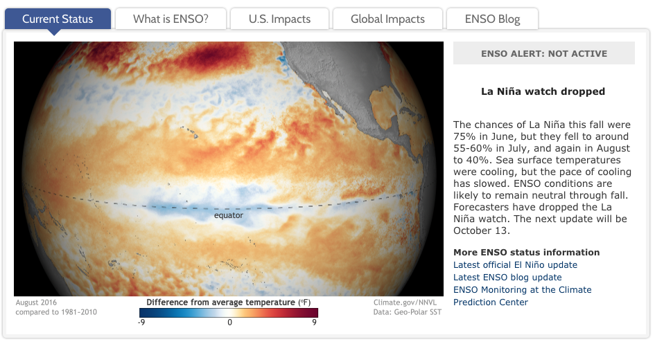
The weather outlook for this winter shifted dramatically over the summer when the sea water temperatures of the Western Pacific cooled more slowly than predicted. To review, El Nino is a “hot” sea water temp, La Nina is “cool”. Both play significant roles in global weather because sea water temps determine which way the surface winds blow which in turn impacts the circulation pattern that connects the tropics with the middle latitudes.
The 2015-16 El Nino was one of the strongest on record. We had huge snows out West and close to nada in the East. This year’s El Nino was declared over in May, 2016. The big bets—and data collected from NOAA ships, buoys and planes—were on for a dramatic La Nina that would basically reverse that prediction.
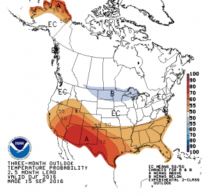
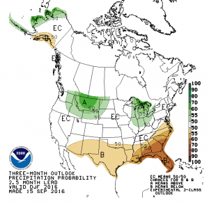
That is not to be. The current data shows the La Nina hasn’t developed as predicted. So, the National Weather Service says we’re headed for a “ENSO-neutral” winter, that is, no La Nina. To cut to the chase, that means—for Jan, Feb, March 2017— below normal temps in the upper mid-west, higher than normal precipitation in Idaho and western Montana (i.e., snow), warmer than normal temps in the southwest with below average precipitation (i.e., warm and dry), and about an equal chance of above, normal or below normal temperatures and precipitation in the northeast. (i.e., you can’t predict it.) From this prediction, it appears the place to ski will be Ontario.
But, be advised, these predictions are based on measures that can and do change randomly. So, stay tuned. We will be watching developments and report the latest when it comes from the National Weather Service.
Here’s a clip from the Climate Prediction Center ENSO site. Worth a visit.