
Big Changes Are Coming Again To Next Season’s Weather.
The image above shows how the sea surface temperature is changing from warm to cooler, signaling the advent of a La Nina event.
Weather scientists are predicting that the sea surface temperatures in the Eastern Pacific will continue to drop, ending the extraordinary, record-breaking El Nino conditions that drove so much of last winter’s weather. When the sea surface water temps drop below .5 degrees C off the coast of Peru, the new La Nina will be in the wings, bringing yet another set of changes to next ski season’s weather. Some reports predict this La Nina can be as dramatically cold as the fading El Nino was warm.
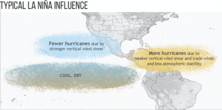
During the summer coming up, the first impact you’ll see will be more hurricanes in the Atlantic. The hurricane season in the Atlantic starts on June 1 and goes to November 30. The prediction is for more storms because of weaker upper level winds.
For the winter months, a typical La Nina pattern will be cool weather in the Northwest, warm and dry across the southern border, and a wet East. Click here for an interesting discussion from the Weather Network.
Fun Fact: La Ninas last longer than El Ninos. The La Nina event that followed the the 1997/98 El Nino lasted 33 months!
Here’s a more technical discussion from NOAA.
Stay tuned for more updates as we watch how La Nina takes shape and how it will impact next winter’s weather.
Credit: NOAA


