Even though we are just a few days past the first day of astronomical summer, I find myself already taking a peek at the northern Rockies when I am working on forecasts for my golf course clients. Why? The skier/weather nerd in me comes out as I look for the first weather station reporting snow in the air. Like you, I am already starting to anticipate the coming winter sports season, so here are my early thoughts on the weather for the upcoming season.
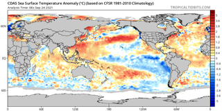
As always, the first thing I do in putting together a long range outlook is to check the status of ENSO…El Nino Southern Oscillation. ENSO is a measurement of the surface water temperature anomalies in the equatorial regions of the Pacific Ocean. When those waters are warmer than the long term average, we have an El Nino. When they are cooler than average, La Nina is present. Last winter we had a La Nina, and another round of La Nina is in storm for us this winter. The following map shows the cooler than normal anomalies already in place in the Pacific basin.
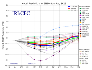
Computer model forecasts designed to focus on ENSO suggest that the La Nina will strengthen in the coming months, as illustrated by this summary of those models. The thick red line is the consensus of the models, and as you can see, that line drops slightly below the -.0.5 Centigrade threshold that indicates La Nina for several months, suggesting that this episode of La Nina will be a weak one, in a fashion similar to last winter.
So, what does that all mean? Well, because the oceans contain 1,000 times the energy that is contained in the atmosphere, the state of the ocean’s water temperature distribution exerts a major influence on what the overlying jet stream looks like. Here is a graphic that shows you the most common jet stream configuration during a La Nina Winter…
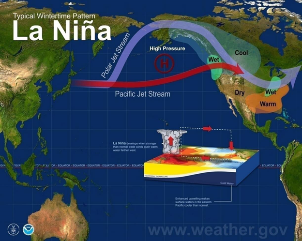
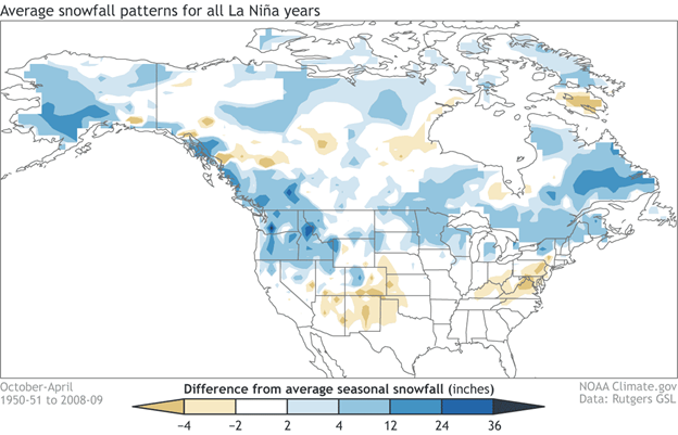
The first thing to note is the confluence of the Polar and Pacific branches of the jet over the northwestern corner of U.S. as well as western Canada. These are two areas that typically have a solid to spectacular season of snowfall in La Nina. The combined jet stream delivers cold air and carves out a trough much of the time across the Great Lakes and Northeast and these two regions also usually benefit from a cool Pacific setup. Across roughly the southern half of the country, La Nina winters can be more of a challenge. That doesn’t mean that the Pacific jet can’t deliver storms to the Southwest…it can, and will…but the more common jet pattern will favor resorts across the northern half of the West. The region that finds a La Nina least desirable is the Southeast. Here, an upper level ridge is more favored, and that leads to milder than normal temps more often than not. Snowmaking will likely be king in the southern Appalachians this season. The final graphic I would like to share with you summarizes snowfall anomalies during La Ninas…