
Progressive Storm Threats Gets Underway
Although it’s likely that the holiday period will be a Covid-induced quiet one across the country, it is now crunch time for opening terrain that will create adequate social distancing to fend off further operating restrictions.
The past week brought about a pattern change that delivered snow to many resorts that had seen very little. Of late, storms have moved into the West, across the continent, and through the East and that trend will continue. Canada has been milder than normal for many weeks, but cold air is now building and becoming available for the storms further south so the potential for more snow in more spots is on the rise. In addition, I am a little less concerned about a holiday eastern warmup than I was last week.
In weather geek language, we are in a “progressive” pattern, meaning jet stream ridges and troughs are moving along from west to east without locking in for an extended stay. That produces changeable weather, but with more cold air becoming available from Canada, we are now talking more about snow and less about rain. There are still forecast challenges with respect to storm tracks, but overall, things are looking up.
In the near term, storms will move southeastward from the Gulf of Alaska and dump on the coastal ranges of British Columbia, Washington, and Oregon. Much of the moisture will get wrung out before the systems reach the northern Rockies, but there will be “topdressing” snow further inland most mornings through next week. The central and northern Sierra will pick up snow later this weekend and early next week with the prospects not as good further south due to the systems tracking too far to the east. Northern Utah and Colorado will cash in on the passage of these quick hitting systems next week but a lack of deep moisture will keep amounts light. The southern Rockies will see little new snow in the next week.
Over the eastern half of the country, disturbances will approach in both the northern and southern branches of the jet stream. Cold air will still be a little scarce in the short term, so the track of any storm will determine where it snows. But the potential is clearly there, as this jet stream forecast for Monday, December 14 clearly illustrates.
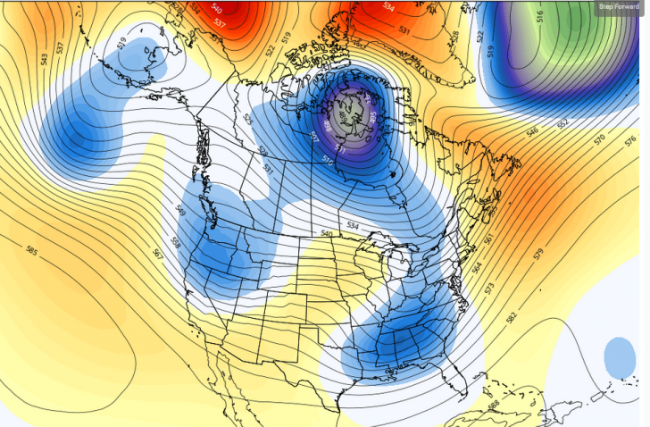
On this map we see a trough over the South, with an extension northward to Canada, a combination that could easily produce snow from the mid-Atlantic resorts up through New England. Notice also the trough along the Pacific Northwest coast and the next in line south of the Aleutians. The deeper trough over northern Canada acts as the center of the wheel, with the other features effectively rotating around it. The orange over Greenland plays an important role for the East in this pattern. That’s an upper level ridge that makes it easier for eastern troughs to strengthen as they approach the Atlantic. Indications are that the ridge will remain in the same general area until late month, so storm threats will be fairly frequent. Each trough that passes by will deliver a chunk of colder air from Canada, so the snowmakers will have ample opportunities as we approach the holidays.
Regional Details
Northwest U.S./Western Canada: Frequent storms from the Gulf of Alaska bring heavy snows every two-three days. Snow levels bounce a bit in Oregon Cascades.
Sierra: Periodic light snows from Tahoe northward until further notice. Minimal snow in southern Sierra.
Rockies: Northern resorts get frequent light to moderate snows. Occasional light snows Wasatch and central resorts. Limited snow prospects further south.
Midwest: Clipper system brings light snow Tuesday and delivers good snowmaking temps and modest lake effect snows.
Mid Atlantic/Southeast: Colder weather arrives Monday. Potential snowfall Tuesday. Good snowmaking week.
Northeast/QB: Mixed precip Sunday. Mountain snow showers Monday. Good snowmaking week with additional storm threats.


