
Snow For All.
Often when I write this piece, I have good news for one region of the country and not-so good news for other areas of ski country. Such is the nature of winter weather across a country that stretches 3,000 miles from coast to coast and with so many and varied climate zones. However, just as there are times in the middle of the summer when much of the country is warmer than normal, occasionally we see a pattern in winter where most or all of the skiing regions get lined up for significant snowfall at roughly the same time. We are entering just such a period.
In order for a favorable pattern to set up for such a large area of the country we obviously need an ample supply of cold air. From mid-December until just recently, most of the air flowing across the country was of Pacific origin, not the prime source region for winter weather. The jet stream configuration now in place is tapping cold air from the northwestern corner of the continent. There is still a risk that we could see an intrusion of severely cold arctic air by the end of the month, but at a minimum, enough cold has showed up to make even southern regions cold enough to be on the lookout for fresh snow. It certainly helps that this is the time of year when normal temps in most areas are right at their climatological minimums for the year. To illustrate the extent of the cold air, here is a look at the forecasted 5,000 foot level for Friday, Jan. 29th

The area shaded in hues of blue indicate where temps will be below freezing. Sub-freezing temps at that level are a proxy for where the column of air overhead is cold enough to support snow, even the southern Appalachians look sufficiently cold.
The other ingredient for widespread snow is a favorable jet stream configuration. Here is a forecast for the jet stream for late next week that I agree with, showing three key components to a snowy pattern from coast to coast.
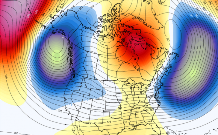
The trough along the west coast will produce fresh snow from Alaska down to the southern Sierra, and inland to AZ and NM as well. Storms from the southern end of that trough will traverse the country and bring the opportunity for snow to the central and southern Appalachians. The red ridge over northeastern Canada will remain in place and help keep storms from cutting through the Great Lakes, which would produce rain to the east of the track. Northern disturbances will come out of the Gulf of Alaska, move along the U.S./Canadian border, and produce snow in the Great Lakes and Northeast from time to time. Those systems are often called Alberta Clippers because they typically move through that province. If the impulses in the northern and southern branches of the jet combine forces, the trough off the east coast will be pulled westward and potentially lead to a blockbuster coastal storm for the mid-Atlantic and Northeast. The potential is high nationwide. Let’s hope the pattern delivers the goods!!!
Regional Details
Northwest U.S./Western Canada: The trough along the coast produces multiple rounds of meaningful snow over the next couple of weeks. No issues with snow levels due to input of arctic air.
Sierra: Trough extends far enough south to produce a much more active storm pattern to this region.
Rockies: Full length of the mountain range will have frequent snow events into early February.
Midwest: Clipper systems keep coming every two-three days into next month. Each one will produce light snow with backside lake effect, as well.
Mid Atlantic/Southeast: Cold enough for snowmaking; southern storm track could generate natural snow at times.
Northeast/QB: Clipper systems help northern resorts with light snow at times. Ridge over Canada likely to suppress major storm track too much UNLESS two jet branches combine for coastal storm.


Thank you Herb,from the west coast