
By the time you read this, a significant snow and ice event will have moved through the Northeast, signaling the start of the pattern change that I alluded to in my last installment. The stratospheric warming event that I discussed in my last installment has matured and now it is time for us to reap the benefits. The polar vortex has been distorted by increasing pressure from the warming above and the cold air contained in the vortex has started to spread out to the mid-latitudes in several parts of the globe.
Colder air has already built up over much of Canada, as you can see from this map of surface temp anomalies from this morning.

Although the core of the colder air is located over the western half of the continent, that cold air will be progressing eastward as we head toward March. In addition, the cold over eastern Canada is poised to be pulled south by the circulation around any sort of low-pressure center that moves through the Northeast. There are two other things I want you to notice about this map. First, the zone that separates the colder than normal from the milder/warmer than normal air masses stretches from Oklahoma to central New England. This “baroclinic zone” is the likely storm track in the near term as low pressure systems feed off the thermal contrast available for energy to support the storm. So, there will still be rain/snow lines to be concerned with, but that zone will be sinking southward as we head into March. Lastly, notice the current warm anomalies over Greenland…those suggest the presence of an upper level ridge overhead and indeed, if we look at this snapshot of jet stream features for the same time we see an upper ridge poking its way into Greenland from the East.

If that ridge strengthens and expands westward over the next couple of weeks, an active storm track will develop underneath it…right through the eastern United States. If we take a look at a jet stream forecast for the end of the first weekend in March, we will see that there is model support for this idea.

The ridge will extend west into northeast Canada with a broad trough covering much of the Lower 48. Energy will come out of the piece of the trough in the Pac Northwest, traverse the country from west to east and feed off the thermal contrast that will still exist from the Ohio Valley to the east coast…that thermal ribbon will be further south, though, and that will mean opportunities for late season snow in the central Appalachians.
Here is a very interesting frame that shows the surface pressure tendencies for the 30 day period following the maturation of a stratwarm event…

The orange area shows high pressure anomalies over Greenland and the polar regions and the blue shows a tendency for low pressure areas along the eastern seaboard…can you say “late season Nor’easter”? A jet stream set up like the ones shown for early March is one that is very favorable for eastern snowstorms. Furthermore, with a strong ridge over Greenland and Canada effectively blocking the progression of systems around the northern hemisphere, the pattern is likely to remain in place for an extended period…perhaps much of next month. Last…and certainly not least, here is a forecast for bountiful snowfall through the first week in April…
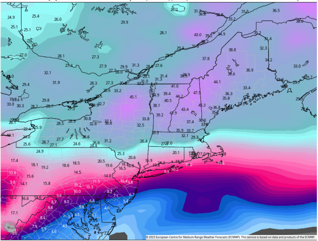
Based on a multitude of factors, some of which I have laid out in this piece, I think that the amounts you see are feasible, if not likely. Better late than never, eh?


Always a delight to read your column, Herb. Such a change from the typical forecasts that are more news than analysis.
Great also with your inclusion of Quebec; because the weather does not stop at the border. Particularly reassuring since we have just shelled out for ski house for a week in mid March !
Brian…I can’t forget my friends up in Quebec. After all, Mont Sutton is my absolute favorite of the 450 or so areas I have skied in my life!
Well I guess everyone needs a hobby but do we really need to be bored to death with the details of it. Evidently it gets cold and snows in the northern U.S. If you really want to talk about a relevant topic that is impacting the sport world wide talk about how climate change is effecting our sport. Without any maps or diagrams I can tell you that winters here in Minnesota are 3 weeks shorter than they used to be. And the damaging effects extend way beyond skiing. At my age there are countless things that now impact my days on the slopes that will never be solved by consulting a bunch of pointless weather maps. Kind of anal if you think about it.
Be nice Thom, not everyone has an attention span like yours. I for one like knowing the why behind why our winter has sucked so bad this year. And then after reading last month’s article about how it was all going to change and relaying that to my friends and then having it actually happen I’m like a genius. So read what you want and skip the parts you aren’t interested in. I’ll admit I didn’t read the whole article either but the parts I did I found very interesting.
If you want to read about climate change and skiing google is your friend. There’s plenty of information out there about that. There’s no doubt it’s happening and it is affecting our ski season. But you learn to adapt. Ditch the 96mm underfoot skis and get some 80mm frontside carvers that can handle the man made snow and ice we ski on now. And save your vacation time until March when the skiing is best now and ski until you drop. Have fun!
Thom:
Try as you might, you will not succeed at trivializing the 50 years that I have spent in my chosen “hobby”. I prefer to call it my profession. Since the day my parents took me out in the eye of Hurricane Donna in Rhode Island as it passed over our house in 1960 I have been fascinated by the majesty and magnitude of the weather. Hard work to learn more about how the atmosphere works afforded me the opportunity to have a successful career and I consider myself abundantly blessed that I can continue to work in the world of weather full-time at this stage of my life.
I am sorry that you have to deal with issues that impact your days on the slopes. I hope that they are not insurmountable. Perhaps on a day that you are not skiing you can consult the Rutgers Snow Lab, where you can find data…not anecdotes…that will show definitively that that northern hemispheric snowfall in the winter months has INCREASED over the past half century. That would involve “consulting a bunch of pointless weather maps (data)” so I suspect you won’t bother to look at “anal” weather records.
Herb, you’re the best and thanks for sharing your knowledge with us. I look forward to what you have to say even though most years the vast majority of the skiable snow falls out west.
You have been prescient about this March in New England, as I look forward to what my humble phone app says will be 22″ next Tuesday in Dover VT. Last weekend we also enjoyed a new foot or so. This year we’re going out with a bang and you called it.