
Your Support Helps!
Help us keep SeniorsSkiing.com free. Please support SeniorsSkiing.com with a donation.
The Skiing Weatherman 3/18 One step forward, one step back…
While Upper Midwestern and western U.S. resorts have seen some meaningful snowfall at times the past 2-3 weeks, areas in the East have battled the back and forth pattern that has been dominant much of this winter. La Ninas typically produce enhanced variability in the winter, and this winter has been a very dramatic example. Significant snowfalls have often been followed by a system that tracked through the eastern Great Lakes into the St. Lawrence Valley, leading to a warmer outcome and rain not long after newly minted snow. Sleet, freezing rain, and strong winds are also eastern hallmarks of La Ninas and we have seen more than enough of all three this season. The result of the changeable weather has been to limit the growth of base snow, and many areas are now in need of fresh snow to ensure that they can stretch their seasons as far as they had planned.
Transition months like March and April are a challenge for forecasters, in large part because the wavelengths between troughs and ridges shorten. The pools of cold air that are available to dynamically support the troughs start to shrink as the hemisphere heads into spring, and more storms become events with marginal temperatures for snow. In addition, the contrast between lingering cold across the north and advancing warmth to the south makes the flow across the country speed up, so changes tend to come often. The following jet stream map, valid on 3/22, illustrates the busy state of the upper levels of the atmosphere…

You can see the trough over the Maritimes, which will help to keep it cool over the Northeast next week, helping to preserve the modest bases. A mild ridge will cover the Midwest, but bases depths there are more substantial. Then you have another trough that will have just produced snow in the central and southern Rockies, with a ridge blanketing the west coast. Gone are the midwinter days of western ridge/eastern trough or vice versa.
This second map shows the pooling of the cold and mild air masses at 5,000 feet associated with the ridges and troughs. The 5,00 foot level is a proxy for surface temperatures.

The fast flow across the country will make it very difficult for either air mass to remain in control at a given location. However, during the week of the 28th, the pattern will slow down somewhat, with a trough favored in the East and a weak ridge in the West, as you can tell from the 5,000 foot temp anomalies on the 29th.
What does this mean? Well, it means some snow will fall in the West, starting this weekend in coastal ranges, and early next week in Colorado. And it suggests that help is on the way to the northern mid-Atlantic and Northeast (next week), where base snow is going to have to fight off some rain this weekend. In the Great Lakes, fresh snow will provide reinforcements for the stretch run, pretty much ensuring a season that will carry on into April. Here’s a map of potential snowfall for the next two weeks…

Regional details…
Northwest U.S./Western Canada: Snowy pattern this weekend into next week, especially in B.C. Snow levels rise thereafter.
Sierra: Light snow this weekend…mild and dry next week. Next snow around the 28th.
Rockies: Substantial snowfall for Colorado late weekend/early next week. Lighter snows northern and southern Rockies.
Midwest: Several snowfalls in the next ten days in the central and northern Great Lakes. Excellent prospects for skiing/riding in early April.
Mid Atlantic/Southeast: Central and northern resorts…at elevation…looking okay for the next 10-14 days. Potential for some snow there late next week. Southern resorts will have to stretch the snow they have on the hill.
Northeast/QB: Some rain will fall this Saturday, ending as snow far north. Cooler next week. Potential for snowfall late next week. The final week of the month looks promising.
The Skiing Weatherman 3/18 One step forward, one step back…
While Upper Midwestern and western U.S. resorts have seen some meaningful snowfall at times the past 2-3 weeks, areas in the East have battled the back and forth pattern that has been dominant much of this winter. La Ninas typically produce enhanced variability in the winter, and this winter has been a very dramatic example. Significant snowfalls have often been followed by a system that tracked through the eastern Great Lakes into the St. Lawrence Valley, leading to a warmer outcome and rain not long after newly minted snow. Sleet, freezing rain, and strong winds are also eastern hallmarks of La Ninas and we have seen more than enough of all three this season. The result of the changeable weather has been to limit the growth of base snow, and many areas are now in need of fresh snow to ensure that they can stretch their seasons as far as they had planned.
Transition months like March and April are a challenge for forecasters, in large part because the wavelengths between troughs and ridges shorten. The pools of cold air that are available to dynamically support the troughs start to shrink as the hemisphere heads into spring, and more storms become events with marginal temperatures for snow. In addition, the contrast between lingering cold across the north and advancing warmth to the south makes the flow across the country speed up, so changes tend to come often. The following jet stream map, valid on 3/22, illustrates the busy state of the upper levels of the atmosphere…
Insert Seniorsskiing1
You can see the trough over the Maritimes, which will help to keep it cool over the Northeast next week, helping to preserve the modest bases. A mild ridge will cover the Midwest, but bases depths there are more substantial. Then you have another trough that will have just produced snow in the central and southern Rockies, with a ridge blanketing the west coast. Gone are the midwinter days of western ridge/eastern trough or vice versa.
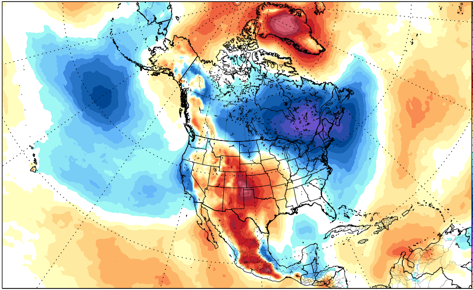
This second map shows the pooling of the cold and mild air masses at 5,000 feet associated with the ridges and troughs. The 5,00 foot level is a proxy for surface temperatures.
Insert Seniorsskiing2
The fast flow across the country will make it very difficult for either air mass to remain in control at a given location. However, during the week of the 28th, the pattern will slow down somewhat, with a trough favored in the East and a weak ridge in the West, as you can tell from the 5,000 foot temp anomalies on the 29th.
Insert Seniorsskiing3
What does this mean? Well, it means some snow will fall in the West, starting this weekend in coastal ranges, and early next week in Colorado. And it suggests that help is on the way to the northern mid-Atlantic and Northeast (next week), where base snow is going to have to fight off some rain this weekend. In the Great Lakes, fresh snow will provide reinforcements for the stretch run, pretty much ensuring a season that will carry on into April. Here’s a map of potential snowfall for the next two weeks…
Insert seniorsskiing4
Regional details…
Northwest U.S./Western Canada: Snowy pattern this weekend into next week, especially in B.C. Snow levels rise thereafter.
Sierra: Light snow this weekend…mild and dry next week. Next snow around the 28th.
Rockies: Substantial snowfall for Colorado late weekend/early next week. Lighter snows northern and southern Rockies.
Midwest: Several snowfalls in the next ten days in the central and northern Great Lakes. Excellent prospects for skiing/riding in early April.
Mid Atlantic/Southeast: Central and northern resorts…at elevation…looking okay for the next 10-14 days. Potential for some snow there late next week. Southern resorts will have to stretch the snow they have on the hill.
Northeast/QB: Some rain will fall this Saturday, ending as snow far north. Cooler next week. Potential for snowfall late next week. The final week of the month looks promising.


Thanks Herb. Good to hear, end of March in NE. Not quite ready for shorts and sandals yet.