
SeniorsSkiing.com’s New Columnist Places His Bet on 2019-20.
[Editor Note: Herb Stevens is a veteran meteorologist and television weatherman. SeniorsSkiing.com is very proud to introduce his new column which will appear weekly throughout the season.]
When a long range weather forecaster starts to put together a winter forecast, the first element that has to be assessed is the state of the water temperatures in the Pacific, especially the tropical region. The oceans hold 1,000 times the heat content of the atmosphere, so changes in water temperature anomalies can produce major influences in the sensible weather, not only in the Pacific, but also downwind of the ocean. El Nino and La Nina are major players in the winter weather over North America and have to be accounted for.
Last winter, a weak El Nino was in place but now the tropical waters have cooled to a neutral level, creating what a forecasting friend of mine refers to as “La Nada”. However, the waters of the northeastern Pacific are much above normal, as the following map indicates.
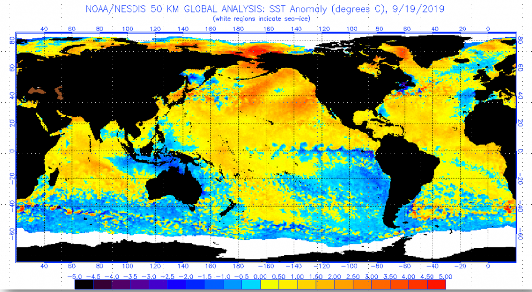
The warm waters support a ridge at the jet stream level over the Gulf of Alaska and western Canada and the clockwise circulation around the ridge can deliver cold air masses into the central and eastern U.S., some with origins in Siberia. Once the ridge forms, you typically see a complementary trough set up over the eastern U.S. Recently, the winters of ‘13-‘14 and ‘14-‘15 had a similar warm pool and jet couplet, and both of those seasons were cold and snowy from the Great Lakes to New England. I rely more on identifying analogs for forecasts rather than leaning on computer models, and the northeast Pacific warm pool creates an impressive lineup of previous winters. Over the past century many of the coldest, snowiest winters over the eastern half of the country have fed off such a warm pool.
Another factor in play this winter is the solar cycle. In terms of sunspots, we are very close to “solar minimum”, when solar output bottoms out which happens roughly every 11 years. This graph illustrates the cycle.

There is a significant correlation between solar minimum and blocking patterns at the jet stream level. With an eastern Pacific upper ridge and eastern North American trough, wavelength considerations would suggest another ridge taking shape over the North Atlantic close to Greenland. With above normal temperature waters also sitting between Labrador and Greenland in the Davis Strait, there would be support for a ridge there. Solar min also correlates with one other weather factor: persistence of a pattern. That is, once established, upper air patterns tend to hang around longer than they do at solar max.
So, based on analog methods, I tend to think that this winter will be favorable for skiing and riding from the center of the country eastward. A possible exception could be the southern Appalachians, where ridging could form and lead to more variability in temperatures at times. The West should be solid for the most part. The northern and central Rockies will be targeted by disturbances sliding down the eastern flank of the offshore ridge. The southern Rockies will benefit from the warmth of the water off of northern Mexico—storms in the southern branch of the jet will have ample moisture, but the ridging along the coast will likely limit the number of storms to an extent. If there is a region that I am concerned about, it would be the Northwest and the resorts of British Columbia, due to the proximity of the anticipated ridge.
That’s my first look at winter. I look forward to providing forecast guidance for your time on the slopes on a weekly basis through the season. I will take another shot at winter in about a month. let’s see what happens to the water temps in by then.


He’s back!! Glad to see that Herb has an outlet for his prescient ski and weather reports. A hearty welcome to the skiing and golfing weatherman!
Hi Herb,
Happy to see your work in Senior Skiers. I hope you can dispel some of the AGW panic. Good luck with your column.
Dave Irons
Forecast for next few days is for blizzards in the Colorado high mountains. But I fear there goes another winter for us in the NW. Really love the info and explanation for what might happen.