
Warmer end to February. March Snow Looks Good.
This has been an absolutely wild weather week across the country, with more heavy snow in the West, the worst run of cold and snow in the southern Plains since 1899, and two significant storms in the East, although the first one generated a fair amount of sleet earlier this week.
As I discussed last week, in the wake of this week’s arctic plunge, the pattern is changing to one with more Pacific air involved, so we are headed toward an end to February that won’t be as cold as much of the month has been. In terms of the jet stream flow, we will continue to see troughs track across the country and those systems will present us with our shots at fresh snow. The troughs won’t have quite as much cold air to work with, though, so snow levels could become a minor issue and rain/snow lines will work into the equation with storms in the Midwest and East in the next couple of weeks. The historic push of arctic air actually drained a good percentage of the available cold air out of Canada. Yes, it is still plenty cold to the north, but it will take a couple of weeks to build the deep cold that can help sustain the season with a southward push during the month of March. Here’s a map that I haven’t shown before. It is a forecast of the standard deviations of temperatures for the next ten days over Canada.
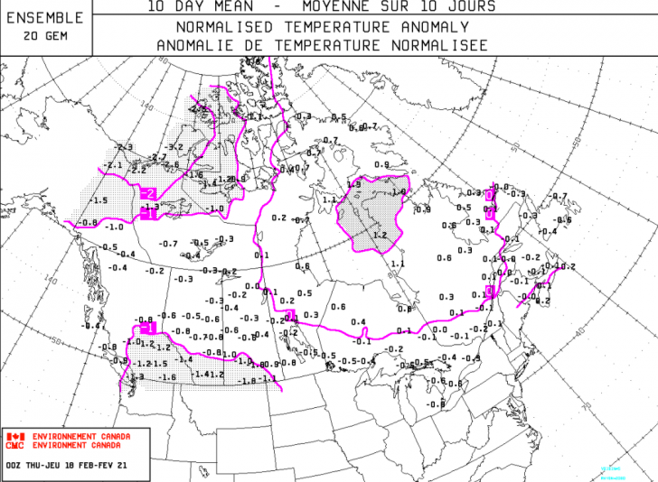
Notice that the values, whether positive or negative, are overwhelmingly close to neutral. Ten days ago, most of the southern third of Canada, centered over Manitoba and Saskatchewan, had negative values of 5 and 6 standard deviations, consistent with an air mass that was 30+ degrees below normal. That is the air mass that plowed all the way down to south Texas in the past week. Those values will be dropping in the near term, as it is still the heart of winter to the north. The question then becomes whether that air will get involved in the pattern over the U.S. in March, when higher sun angles, rising normal temps, and longer days can start to take their toll on surface conditions and base depths. Right now the prospect for a turn to colder weather looks promising for early March. Not harsh cold, but a little below normal. Again, the final week of this month will be milder over the East, while cold persists in the West, but this map of 5,000 foot temperature anomalies for March 5th shows cold air over the East and an ample supply sitting over Canada for reinforcements. The five thousand foot level is a proxy for surface temps.

So, although the pattern will moderate for the East in the short term, it won’t last long and the prospects for March look good at this point, although a typical La Nina upper ridge could bring the southeastern season to a premature end.
REGIONAL HIGHLIGHTS:
Pac NW/B.C.:
Snowy pattern carries on. Snow levels rise a bit early next week before settling back down.
Central and southern Sierra:
Light weekend snow, milder during the week of the 22nd. Pattern cools down and snow opportunities return next weekend.
Rockies:
Pacific flow brings light to moderate snow every day or two Wasatch and Tetons northward. Northwest trajectory brings occasional light snow events central and snow is more scarce until late next week farther south.
Midwest:
A little milder than normal and with a few light snow events in the next week in MN, WI, and northern MI. A great time to hit the slopes, very comfortable.
Northeast:
Not as cold as past few weeks. Weaker Clipper systems bring light mountain snow every few days. Lower elevation resorts see light mixed precip with surfaces softening/moistening somewhat.
Mid-Atlantic/Southeast:
Light mountain snow 22nd, then milder. Spring surface develops in all but the highest resorts next week.


Your weather report is excellent, just detailed enough, and just what I want to hear for the Pac. N.W. Thank you for all your time spent on giving us such great reporting.
Thank you very much, Patricia!
Herb Stevens