A Comeback For The East And Midwest, More Pow For The West.
I spent the first two days of this week with fellow members of the North American Snowsports Journalists Association at Windham Mountain, NY, where the crew did an outstanding job of providing a fun surface in the wake of a mid-season meltdown last Sunday. One of the presentations was by Masterfit University, an outfit that boasts having the best boot fitters in the world. It was a fascinating seminar, and after spending a couple of hours one on one with Windham’s Masterfit representative, I came away convinced that if you want to maximize your skiing, you absolutely should find a Masterfit shop in your area.
While this week started on an unseasonably mild note in the East, the skies kept unloading in parts of the West. A persistent series of low pressure centers loaded with Pacific moisture has utterly buried resorts in Washington, Oregon, northern Idaho, the Tetons, and northern Wasatch in the past week with anywhere from three to six feet of new snow. Lookout Pass in Idaho checked in with a 101 inch storm total! Lighter snows fell elsewhere in the West, and if you are heading in that direction, you can’t make a bad choice right now.
In the Midwest and East, a major pattern change is getting underway, one that delivered some fresh snow in the mountains of the Northeast late this week, with another round coming this weekend. For the first time in weeks, once the low pressure center moves through the Great Lakes and East, a bonafide cold air mass will follow in its wake, leading to great snowmaking conditions and productive lake effect snow in favored snowbelt areas, especially the upper peninsula of Michigan.
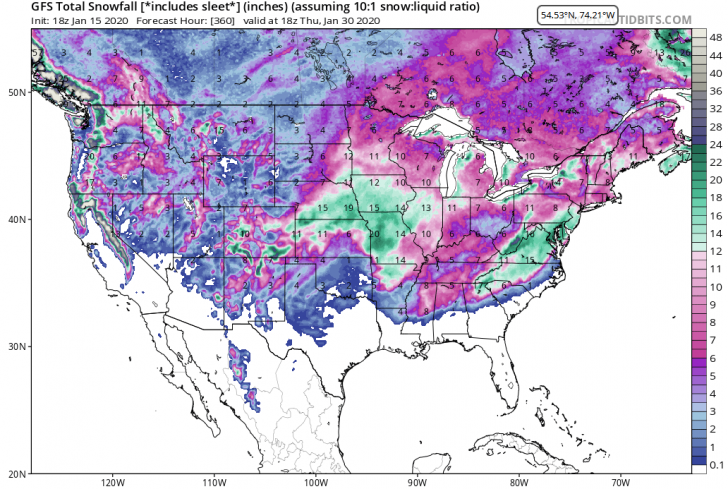
Over the next 10 to 14 days, temperatures will be stepping down over the eastern half of the country as an upper level trough becomes the dominant jet stream feature. At the same time, an upper level ridge will be found more of the time in the Northwest, so the “snow hose” that has been pointed at that region lately will back off quite a bit. The southern Sierra and southern Rockies could see periodic snows as disturbances in the southern branch of the jet move through that part of the country. If a southern branch disturbance manages to phase with energy in the eastern trough, we could see a major storm in the East before too long. The pieces will all be there soon and hopefully they will come together. For your viewing pleasure, here is a forecast map of snowfall for the next 15 days. Don’t focus on one specific spot as much as take note of the breadth of the area, particularly over the eastern half of the country, where significant snow is forecast. The pattern is rounding into shape for meaningful snow events, but the devil will be in the details.

There is reason to believe that once the colder pattern gets established in the Midwest and East, it will remain in control much of the time going forward. My analog years suggest it, as does this jet stream map for two weeks from now:

The broad trough that you see for late this month looks cold and stormy to me.
Here AreThe Regional Details
Northwest U.S./Western Canada: Another rather snowy week coming up, but the recent amazing rate of snowfall will start to back down as an upper ridge takes up residence.
Cascades and Sierra: Snowy (Cascades) into the middle of next week, although snow levels will be a little high late this weekend before settling back down. Lighter snows Tahoe area. Snowfalls back off late this month as ridging develops.
Rockies: Dry weekend into midweek when a new trough will bring some light snow. Longer term, central and southern Rockies favored for snow thanks to disturbances in the southern branch of the jet stream
Midwest: Arctic air dominates for the foreseeable future. Each frontal passage sets off lake effect snow. Great spell of snowmaking temps underway and conditionS. Trail counts will be improving.
Northeast/QB: Moderate snow event this weekend (north of I-80) starts the comeback. Great snowmaking temps for several days in the wake of the storm. Another sizeable snow threat next weekend. Conditions and trail counts will be getting better each day until further notice.


What is a “snow threat”? Is that a threat of snowy weather (I hope so), or is that a threat (from rain or warm weather) to the snow already on the ground? I love being threatened with too much snow.
The comment is posted on behalf of Herb Stevens, the Skiing Weatherman.
“In my weather world, ‘snow threat’ is a positive. Perhaps I should refer to it as a ‘snow opportunity’ in the future. Thanks for drawing my attention to this.”