
Terrain Opens Coast to Coast
In my mind, the end of January is roughly the mid-point of the season and as we hit that mark, the slopes of North America are in good shape from coast to coast. There are a few spots here and there where trail counts and base depths are lacking a bit, but overall, the very active weather pattern of late has helped resorts in just about every winter sports region. A persistent Pacific trough has absolutely pounded the southern Sierra and Southwest this past week, with the amount of open terrain skyrocketing in the past several days. That trend will continue this weekend, pending avalanche work to ensure skier/rider safety. The parade of storms across the country will continue in the upcoming week, with the northern mid-Atlantic and Northeast in line for a significant snowfall to kick off February. At the same time, another juicy Pacific storm will bring new snow along the full length of the Cascades and Sierras, from Mount Baker, Washington in the north to Mammoth Mountain in California. We will likely have two major winter storms going at the same time, as suggested by this jet stream map outlook for Monday night.
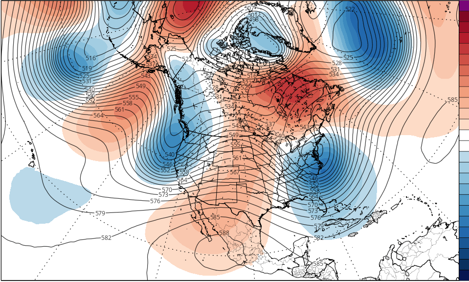
The upper level low centered over Cape May, NJ, will be supporting a surface low that will spin south of New England, a classic Nor’easter track. The orange area over northeastern Canada is a blocking ridge, a feature that will not move out of the way, and that will slow down the progress of the coastal low and result in heavier snow amounts from the central Appalachians into central New England. Heavy snow will fall with the trough off the Pac NW coast on Sunday and Monday, and as the trough pivots east-southeastward, Monday and Tuesday will bring a couple of feet of snow to the southern Sierra. By the end of next week, the western trough will be positioned east of the Rockies, as you can see on this jet stream forecast for the afternoon of Friday the 5th.

The deep trough over the center of the continent will result in a surface low cutting from the southern Plains through the Great Lakes, which will bring a welcomed snowfall to the northern Lakes, but a messy storm farther east, where the deep southwesterly flow will bring a warmup that will last for several days. Meanwhile, along the west coast, a strong upper ridge will build and help to deliver a cold air mass to the Rockies. The very cold air will also move into the Plains and Midwest in the wake of the passage of the surface low next weekend, and then spread into the East early in the week of the 8th. By the time we reach the second week of February the overall pattern will be cold pretty much from coast to coast, and I anticipate a favorable pattern for snow and cold to persist through much of the month.
REGIONAL HIGHLIGHTS:
Pac NW/B.C.:
Early week storm brings another dump…dry and colder pattern develops thereafter.
Central and southern Sierra:
VERY snowy pattern brings another round early in the week. Drier pattern develops later in the week as trough departs.
Rockies:
Light to moderate snow northern resorts middle of next week. Heavy snow central and southern Rockies as core of trough passes through. Colder throughout after the storm.
Midwest:
Cold pattern in place. Western Lakes in line for significant snow later next week…mixed precip central and eastern Lakes. Lake effect snow follows passage of storm.
Northeast:
Cold weekend. Major storm from central Appalachians to central New England Monday/Tuesday. Lighter amounts across the far north. Messy mixed precip event late next week.
Mid-Atlantic/Southeast:
Moderate to heavy snow early next week. Turning milder with late week rain event. Colder thereafter.


This is such great news for everyone!!!
Let’s hope you’re right. Thus far, Utah and Colorado have had one of the worst snow seasons in memory. Snowpack is the fourth lowest since they began measuring.