
The Skiing Weatherman 4/1 West favored for snow…East hangs on
In my last installment, I discussed the extreme back and forth nature of the winter in much of the country, as well as the transition of the upper air pattern to a typical springtime short wavelength configuration that helps to sustain a rapid back and forth sequence of weather systems. For the next 10 days or so, we are looking at pretty much a “rinse and repeat” scenario from coast to coast. Cold air is still quite plentiful across Canada, but it is more difficult at this time of year to break off a big chunk that descends into the lower 48 for an extended period of time. We will have to make do with smaller shots of cold air that fuel and sustain transient upper level troughs, but we’ll also have to accept the short wavelength ridges that move from west to east that lead to milder weather and spring surface conditions. By the middle of the month, I do see signs of a colder pattern setting up in the West, with a mild ridge popping up in the East, one that will likely be the knockout punch for the season at most of that region’s resorts. Here is a look at the jet stream next Thursday…

A deep trough will be located over the middle of the country, with ridging dominating the West with a spell of dry, mild weather. It will also be mild in the East…after a chilly start to the week…as a ridge also pops up along the Atlantic seaboard. The trough will send yet another surface low-pressure center along an unfavorable path for eastern resorts through the eastern Great Lakes and into the St. Lawrence Valley. That track will generate rain and some higher elevation snow in New York and New England. While eastern skiers and riders have cursed the numerous “cutter” lows this season, the far northern Great Lakes resorts have been on the snowy side of that storm track and have enjoyed a banner season. Mount Bohemia in the Upper Peninsula of Michigan is a natural snow, ungroomed, advanced skier-only powder magnet in the Lake Superior snowbelt. They average about 270 inches of snow a year and have received 280 inches as of 3/24. As this list illustrates, Bohemia has racked up more snowfall than many more famous resorts, east, and west.
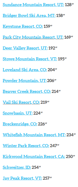
With the potential for additional snowfall looking pretty solid across the northern Lakes, Bohemia could very well stretch their lead on the snowfall scoreboard through mid-April.
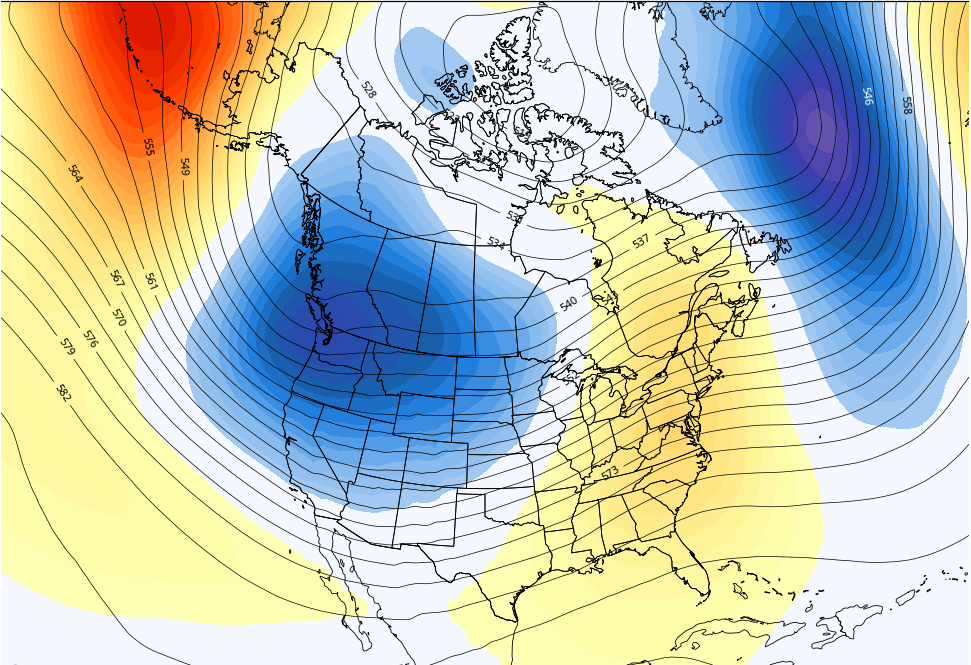
Out west, snow levels have been on the high side of late, with spring conditions quite common, even into parts of the northern Rockies. The relatively mild pattern will remain in place for the next week, but by about the 10th, a significant trough will move in from the Pacific, and colder air will flow into that trough from western Canada. That will lead to a period of at least several days with enhanced prospects for late snow from the Cascades down through the Sierras and eastward to the Rockies. At the same time a mild ridge will build in the East, and with rather a skimpy base snow in place, the end of the season will arrive at many resorts. Here is a jet stream forecast for 4/13 that displays the pattern change.
Regional details…
Northwest U.S./Western Canada: Some light snow early next week, then mild and dry. Turns snowy from the 10th onward.
Sierra: Spring conditions rule for another 10 days before mid-month pattern change delivers snow.
Rockies: Weak system brings light snows early next week then ridge rules for a while. Pattern favorable for late snow after the 11th or so.
Midwest: Many resorts have closed. Snow still in the cards across the northern Lakes for the next couple of weeks.
Mid Atlantic/Southeast: Boom-boom, out go the lights. The season is over.
Northeast/QB: Chilly weekend sustains snow cover. First ten days of April hold hope for high elevation snow at northern resorts.


What about Wolf Creek Colorado– 377 as of April 3